|
|
full country name |
|
Lao People's Democratic Republic |
| capital |
|
Vientiane |
| population |
|
5.4 million (as of 2001) |
| surface area |
|
236800 sq km |
| currency |
|
kip |
| exchange rate |
|
US$ 1 = kip 10605 (as of March 2003) |
| language |
|
Lao |
| main religion |
|
60% Buddhist |
| Internet users |
|
0.037% (as of 2000) |
|
| The Land of a Million Elephants |
| In the 19th century, Laos was called Lan Xang, the land of a million elephants. In the 1960's, it became the land of the million irrelevants, forgotten by the world and more heavily bombed per ... (more) |
|
| What's Happening in the World? |
| 13 months and 13 countries later, we are in Laos. Like with any country, we visit a part of this one. Unlike with any other country so far, one of the reasons we have chosen this part - the ... (more) |
|
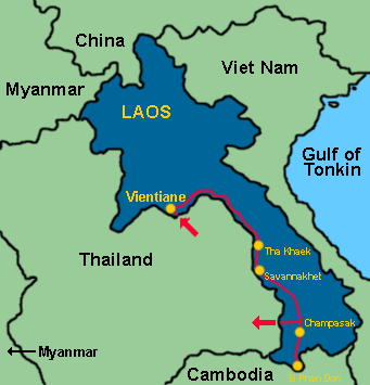
On March 10th, 2003, at Nong Khai, we crossed the Friendship Bridge over the Mekong, leaving Thailand and entering Laos. We spent a few days in Vientiane, visiting Pha That Luang (the holiest - and most yellow - place in Laos), Xieng Khuan (a Buddha park at the outskirts of Vientiane), and among many other wats, Wat Si Saket with its thousands of Buddha niches in the surrounding cloister and beautiful murals inside the temple. We slept deeply after a relaxing herbal sauna at Wat Sok Pa Luang, and enjoyed like anywhere in Laos, French-influenced food such as baguettes with pâté. Compared to Myanmar's Yangon, Vientiane is a small city with some colonial architecture but no four-story or higher buildings. The view from Patuxai, Vientiane's version of the Arc de Triomphe, shows exactly that: a wat peeking out from behind green trees, the Mekong, wide streets, but no skyline.
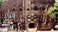
After Vientiane, we started heading south, visiting Tha Khaek, driving through limestone country near Mahaxai with rivers and caves, and wandering the colonial streets of Savannakhet. Further south close to Champasak, we experience a taste of Angkor-style temples at Wat Phu, beautifully lined with plumeria trees, Laos' national tree. During our last week, we stayed on Don Det, an island in the Mekong not far from the Cambodian border. Don Det is situated in Si Phan Don (Four Thousand Islands) of which only some are inhabited year round, even in the rainy season when the Mekong reaches a width of 14km and submerges many of the smaller islands. On March 27th, 2003, we crossed the border at Chong Mek, arriving in Thailand for the fifth time in the last five months.
|
|